Praefecturae Paranambucae pars Borealis
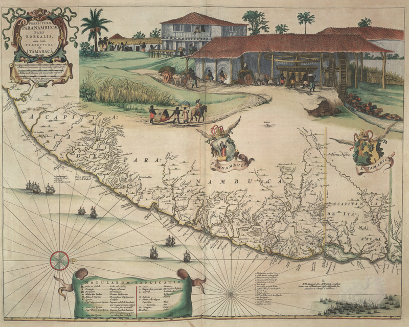
"Office of Pernambuco Northern Region" (caption translation). This engraving of a map of Brazil includes an inset image showing a sugar plantation and enslaved people engaged in various tasks. In the center, a group is transporting a planter's wife in a hammock. Also shown were various plantation buildings, including the manor house or great house and a vertical roller sugar mill powered by water. Frans Post and Georg Marcgraf made this engraving. Frans Janszoon Post (1612–1680) was a Dutch painter. In 1636, he traveled to Dutch Brazil where he produced a large number of sketches and etchings, but only completed six paintings. In his lifetime, he made 140 paintings. The paintings he produced in Brazil differ from those he painted after he left Brazil. Georg Marcgraf (1610–c.1644) was a German cartographer and astronomer who also traveled to Dutch Brazil. See image NW0062.
Image Title
Praefecturae Paranambucae pars Borealis
RegID
SI-OB-977
Date
1640
Title
Praefecturae Paranambucae pars Borealis
Source
Joan Blaeu, Atlas maior, sive, Cosmographia Blaviana: Qua solum, salum, cœlum, accuratissime describuntur, vol. 11 (Amstelædami: Labore & sumptibus Ioannis Blaeu, 1662), between p. 243 and 245.
Language
Dutch
Item sets
Plantation Scenes, Slave Settlements & Houses
Spatial Coverage
South America--Brazil--Pernambuco
Researchers
Jerome Handler; Michael Tuite; Blanche Ebeling-Koning; Henry B. Lovejoy Graduate Research Assistants: Tiffany Beebe; Travis May
Last Updated
2007; 4-Sep-19
Identifier
blaeu04a