Huts at Joggùh
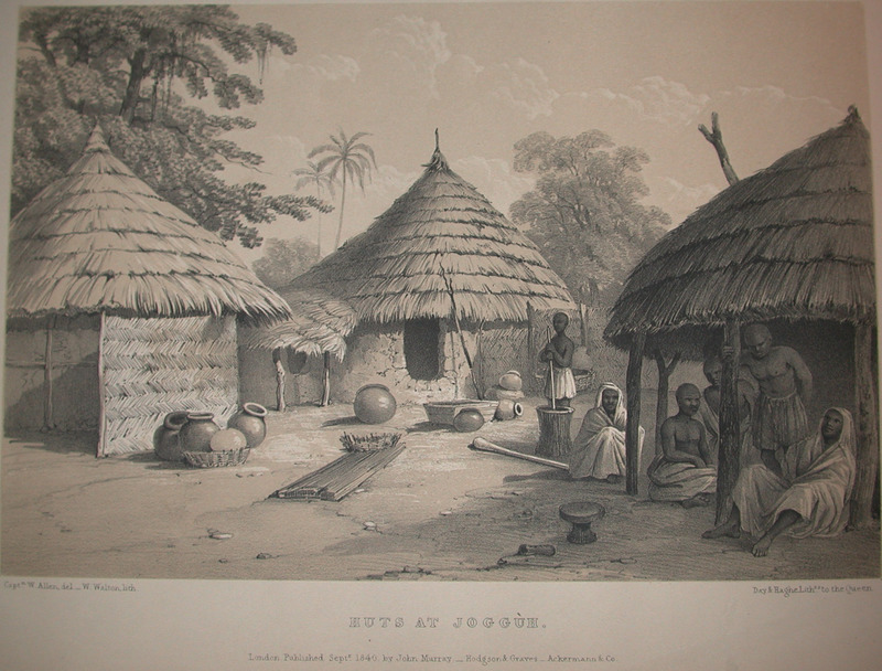
This engraving shows a town with circular, thatched-roof house and people sitting out front. Allen explained how the houses "usually contain but one chamber each; although sometimes a small space is partitioned off for a store or lumber closet. A few have flat ceilings of palm branches laid diagonally, but they are mostly open to the apex of the high conical thatched room, and abundantly garnished with cobwebs. The floor is of mud, sometimes tessellated with bits of earthenware jars; more frequently, however, it is simply the rough uneven ground. . . The only admission of light and air, is by a small doorway. . . The meals are always eaten in the open air, or under verandahs formed by the projecting thatch of the roof, where the master of the house luxuriates with his friends, sending forth volumes of smoke. . . The dwelling [depicted in the illustration] may be considered as a fair specimen of the residence of a respectable individual" (Allen, p. 11). On a contemporary map "Joggùh" was plotted on the western side of the Niger/Benue confluence in the Bight of Benin hinterland. This term may also refer to the kingdom of Jukun, but these people are primarily located in the Benue River basin to the east of the confluence. Even though the reference to "Joggùh" cannot be easily identified, it might have been a pre-colonial town that existed at the site of present-day Lokoja, which emerged in the second half of the nineteenth century as the capital of the British Northern Nigeria Protectorate. William Allen (1792–1864) was an English naval officer and explorer. He took part in the Niger expedition to map the course of the river.
Image Title
Huts at Joggùh
RegID
SI-OB-862
Date
1840
Title
Huts at Joggùh
Source
William Allen, Picturesque views on the river Niger, sketched during Lander's last visit in 1832-33 (London: John Murray, 1840), facing p. 11.
Language
English
Item sets
Pre-Colonial Africa: Society, Polity, Culture
Spatial Coverage
Africa--Western Bight
Researchers
Jerome Handler; Michael Tuite; Henry B. Lovejoy Graduate Research Assistants: Tiffany Beebe; Travis May
Last Updated
10-Feb-17; 27-Aug-19
Identifier
Allen13