The Interior of the Chief Malem's House
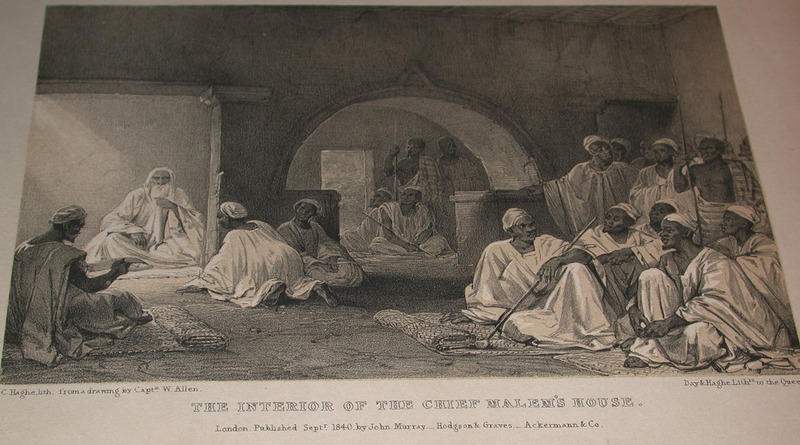
This engraving shows the ruler of the kingdom of "Fandah," which refers to Panda (Opanda) in the Bight of Biafra region. The kingdom was plotted on a contemporary map to the north of the Benue River and east of the confluence with the Niger River. Allen described how he "had received a message that Ibrahim, the head Malem, wished to see me. Following his guide, he entered a court-yard filled with people. On the opposite side was a square building having more pretensions to architectural design, than any I had seen. On each side of a low doorway, were placed a drawn dagger and a book. I entered. . . a large apartment dimly lighted and filled with people. It was divided by a wall through which were three openings; that in the center being an archway ornamented with a moulding. Through one of these I was led to a venerable man, who sat alone on a white bull's hide, his elbow resting on a cushion. . . He gave me to understand that he was the High Priest among the Mahomedans; and expressed himself highly gratified at my visit. . . The courty-yard was filled with devout loungers, who attended the Malem's levee. . . Other courts on each side were occupied by the numerous wives, children, and slaves of the Patriarch" (p. 15). William Allen (1792–1864) was an English naval officer and explorer. He took part in the Niger expedition to map the course of the river.
Image Title
The Interior of the Chief Malem's House
RegID
SI-OB-859
Date
1840
Title
The Interior of the Chief Malem's House
Source
William Allen, Picturesque views on the river Niger, sketched during Lander's last visit in 1832-33 (London: John Murray, 1840), facing p. 15.
Language
English
Item sets
Pre-Colonial Africa: Society, Polity, Culture
Spatial Coverage
Africa--Eastern Bight--Opanda
Researchers
Jerome Handler; Michael Tuite; Henry B. Lovejoy Graduate Research Assistants: Tiffany Beebe; Travis May
Last Updated
10-Feb-17; 27-Aug-19
Identifier
Allen10