Prospect of the European Factorys at Xavier or Sabi
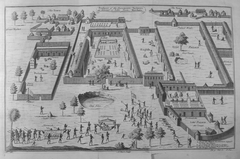
This engraving depicts an overhead view of Savi, including about 50 buildings and locales, which are individually identified and named, including the Portuguese, French, and British slave trading forts, palaces, compounds, courts and other town buildings. Various inhabitants and armed soldiers are milling about. Savi was the capital of the kingdom of Whydah in the Bight of Benin region. In 1727, Whydah was conquered by King Agaja of the kingdom of Dahomey, which helped transform the latter into a significant regional power. According to Robert Harms, "The city of Savi. . . was about four miles in circumference. It was so populous that the throngs of people made it difficult to pass along the streets. . . The daily markets featured all sorts of European and African commodities. Near the European compounds was a square shaded by tall trees where the English, French, Dutch, and Portuguese directors, merchants, and sea captains sat and transacted daily business, much like a European mercantile exchange" (see The Diligent (New York: Basic Books, 2002), p. 156).
Image Title
Prospect of the European Factorys at Xavier or Sabi
RegID
SI-OB-827
Date
1745-1747
Title
Prospect of the European Factorys at Xavier or Sabi
Source
"Plate IX" in Thomas Astley (ed.), A New General Collection of Voyages and Travels, vol. 3 (London: Thomas Astley, 1745-1747), facing p. 64.
Language
French
Item sets
European Forts & Trading Posts in Africa
Spatial Coverage
Africa--Western Bight--Savi
Reproduced In
Derived from "Comptoirs des Europèens a Xavier" in Jean Baptiste Labat, Voyage du Chevalier des Marchais en Guinee. . . fait en 1725, 1726, & 1727, vol. 2 (Amsterdam: Aux dépens de la Compagnie, 1731), p. 40-41.
Researchers
Jerome Handler; Michael Tuite; Henry B. Lovejoy Graduate Research Assistants: Tiffany Beebe; Travis May
Last Updated
19-Feb-16; 26-Aug-19
Identifier
Astley019