Cape Mount and Cape Mesurado (Monrovia), Liberia, 1840s-1850s
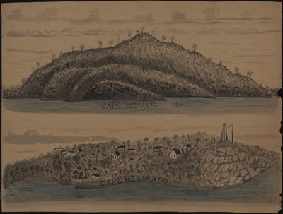
Ink, watercolor, pencil. In 1822, the American Colonization Society established the settlement at Cape Mesurado, later named Monrovia. Among other features, this drawing shows the rectangular houses of the settlers and the circular houses of the indigenous population (Bassa?); churches are also shown. The promontory on the right has a flagpole (another is on the left) and lighthouse. The latter is probably the first lighthouse at Cape Mesurado, erected in 1836. The drawing of Cape Mount does not display man-made features. Sources: Harry Johnston, Liberia (Dodd, Mead, 1906); Richard Hall, On Africís Shore (Baltimore, 2003). See other image references UVA on this site. For background to this and other UVA images, see image reference UVA01.
Image Title
Cape Mount and Cape Mesurado (Monrovia), Liberia, 1840s-1850s
RegID
SI-OB-1204
Date
1840-1850
Title
Cape Mount and Cape Mesurado (Monrovia), Liberia, 1840s-1850s
Source
Drawings of Western Africa (University of Virginia Library, Special Collections, MSS 14357, no. 28).
Language
English
Item sets
Pre-Colonial Africa: Society, Polity, Culture
Spatial Coverage
Africa--Rivers
Researchers
Handler, Jerome; Tuite, Michael; Randall Ericson; Henry B. Lovejoy Graduate Research Assistants: Tiffany Beebe; Travis May
Last Updated
27-Jun-17
Identifier
UVA24