View of a Sugar Plantation, French West Indies, 1762
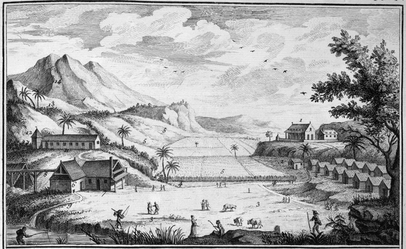
This illustration is a generalized view of what is supposed to be a typical sugar plantation in the French West Indies. Details of the illustration are given in Diderot, section on Agriculture, p. 11. For example, on the upper right (1) is shown the houses of the owner and overseers (surrounded by a fence); on the lower right, the houses of the slaves, forming one or two or more streets, depending on the size of the plantation (2); sugar cane fields in the center and left (5); the water mill for grinding canes is on the lower left (6) and the boiling house (7) next to it; the curing house, where the sugar is dried in pots is on the upper left (12), and fields devoted to food crops such as manioc and bananas are on the upper slopes to the left (13). A slightly altered and reversed version of this image is in M. Chambon, Le commerce de l'Amérique par Marseille (Avignon 1764), Vol. 1, plate V, facing p. 382.
Image Title
View of a Sugar Plantation, French West Indies, 1762
RegID
SI-OB-1201
Date
1762
Title
View of a Sugar Plantation, French West Indies, 1762
Source
Denis Diderot, Encyclopédie, ou, Dictionnaire Raisonné des Sciences, des Arts et des Metiers . . . Recueil de Planches, sur les Sciences . . . (Paris, 1762), vol. 1, plate I. (Copy in Special Collections Department, University of Virginia Library)
Language
French
Item sets
Plantation Scenes, Slave Settlements & Houses
Spatial Coverage
Caribbean
Reproduced In
Denis Diderot, Encyclopédie, ou, Dictionnaire Raisonné des Sciences, des Arts et des Metiers . . . Recueil de Planches, sur les Sciences . . . (Paris, 1762), vol. 1, plate I.
Researchers
Handler, Jerome; Tuite, Michael; Randall Ericson; Henry B. Lovejoy Graduate Research Assistants: Tiffany Beebe; Travis May
Identifier
sucrerie_plate1