Cape Coast Castle, Ground Plan, 1756
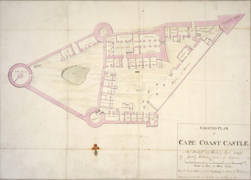
Surveyed in March 1756 by Justly Watson, Director of Engineers, this colored manuscript plan shows storerooms, warehouses, apartments for European personnel, etc. In the upper right hand corner (marked by the letter A) is the women slave yard. The inset contains a note saying The figures 1654 are upon the keystone of the arch to the warehouse. (See also, Cape Coast Castle, Upper Plan, image reference PRO-3 on this website).
Image Title
Cape Coast Castle, Ground Plan, 1756
RegID
SI-OB-103
Date
1756
Title
Cape Coast Castle, Ground Plan, 1756
Source
The National Archives, London (formerly, Public Record Office), (MPG 1/233); see Comments.
Language
English
Item sets
European Forts & Trading Posts in Africa
Spatial Coverage
Africa--Voltaic--Cape Coast
Researchers
Handler, Jerome; Tuite, Michael; Randall Ericson; Henry B. Lovejoy Graduate Research Assistants: Tiffany Beebe; Travis May
Last Updated
15-Feb-16
Identifier
PRO-2